


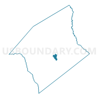
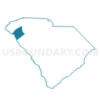
Broadview Voting District, Anderson County, South Carolina
About
Outline

Summary
| Unique Area Identifier | 665022 |
| Name | Broadview Voting District |
| County | Anderson County |
| State | South Carolina |
| Area (square miles) | 2.92 |
| Land Area (square miles) | 2.76 |
| Water Area (square miles) | 0.15 |
| % of Land Area | 94.71 |
| % of Water Area | 5.29 |
| Latitude of the Internal Point | 34.46479570 |
| Longtitude of the Internal Point | -82.59964030 |
Maps

Graphs
Select a template below for downloading or customizing gragh for Broadview Voting District, Anderson County, South Carolina


Neighbors
Neighoring Voting District (by Name) Neighboring Voting District on the Map
- Anderson 3/2 Voting District, Anderson County, SC
- Anderson 4/2 Voting District, Anderson County, SC
- Hall Voting District, Anderson County, SC
- Homeland Park Voting District, Anderson County, SC
- Neals Creek Voting District, Anderson County, SC
- Shirleys Store Voting District, Anderson County, SC
Top 10 Neighboring County Subdivision (by Population) Neighboring County Subdivision on the Map
Top 10 Neighboring Unified School District (by Population) Neighboring Unified School District on the Map
- Anderson School District 5, SC (78,592)
- Anderson School District 2, SC (22,394)
- Anderson School District 3, SC (15,156)
Top 10 Neighboring State Legislative District Lower Chamber (by Population) Neighboring State Legislative District Lower Chamber on the Map
- State House District 9, SC (36,394)
- State House District 8, SC (35,520)
- State House District 7, SC (32,794)
Top 10 Neighboring State Legislative District Upper Chamber (by Population) Neighboring State Legislative District Upper Chamber on the Map
Top 10 Neighboring 111th Congressional District (by Population) Neighboring 111th Congressional District on the Map
Top 10 Neighboring Census Tract (by Population) Neighboring Census Tract on the Map
- Census Tract 113, Anderson County, SC (7,234)
- Census Tract 118, Anderson County, SC (4,051)
- Census Tract 6, Anderson County, SC (3,084)
- Census Tract 5, Anderson County, SC (2,875)
- Census Tract 119.02, Anderson County, SC (2,829)